Maps are historic treasures. Maps graphically compile a wealth of information in a compact, highly organized, and easy to digest manner. I love maps.
I have picked two very different maps depicting the Williams Creek Basin and the surrounding area and I will opine a bit about both.
The first map is interesting not for what it shows, but what it does not show. It is the “Map of the State of Kentucky with the Adjoining Territories – 1795.”1795 KY Map
Here is a small section of this map that includes the current counties of Greenup, Carter, and Boyd, and bits of some other adjacent Kentucky counties, and part of southern Ohio.

- This entire Kentucky area is Mason County. The counties of Greenup, Carter and Boyd were formed later.
- There is absolutely nothing cited on this map section other than the rivers and creeks. Nothing. In other locations on this same Kentucky map there are many communities and towns.
- Well there actually is one mysterious cited community, “Balclutha”.Register KY Hist Soc, p241, 242 This is the community that eventually became Louisa KY, at the confluence of the Tug and Levisa forks of the Big Sandy. “Balclutha” is Scottish Gaelic and would be spelled Baile Cluaidh in that language; this translates into English as “Town on the River Clyde”.Balclutha Scotland This is a fitting name for a community along a river, the Big Sandy.
- So in 1795 there are no significant communities in The Williams Creek Basin, or in what is currently Greenup, Carter, or Boyd Counties. There may be a few people here and there, an enterprising family here or there, and possibly a few Native Americans living a nomadic existence, but no collection of people in any community. This area is largely uninhabited.
- The important information in this map portion is the lack of communities in 1795.
The second map, 3/4 of a century later than the first, and a century after the formation of the United States, is a “Kentucky Geological Survey of the Counties of Greenup, Carter, Boyd and part of Lawrence” from 1876.1876 NEKY Map
Here is a small part of this map that shows the Williams Creek Basin area and the immediate surroundings.

Some interesting aspects of this map.
- The railway, then called the “Lexington and Big Sandy Railroad – Eastern Division”, was coming from Ashland KY and dead ends at Rush. This railway had yet to make the turn west at Geigerville and head up the valley created by Williams Creek. Later, in 1881, an extension along Williams Creek continued west to Lexington KY, and by then this section of the railway had a new name, the “Ashland Coal and Iron Railway (AC&I)”.
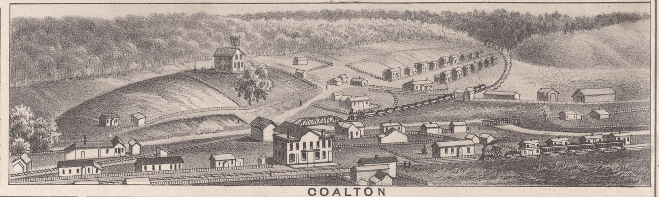
- There is a spur rail coming off the main railway at Coalton heading toward what is now called Big Run. This railway is servicing the large and rapidly expanding drift mine operation centered at Coalton. This coal is providing fuel for the iron furnaces in Ashland KY.
- There is another spur rail line coming off the main line at what is now called Kilgore, and proceeding to the area around the Star Furnace, which at the time of this map’s publication had been out of operation for three years. This railroad was servicing a significant coal drift mining operation on the expansive Star Furnace land holdings that had been purchased by the Norton Iron Works of Ashland.
- Note the name of the creek beside Star Furnace. It was at this point called “Rachel Branch”. The name of this creek, “Rachel Branch”; has mostly been supplanted by “Star Branch” or “Star Creek”. There are a few hardheads in the area that still call this creek “Rachel Branch”.
- There are significant communities shown at Coalton, Rush Station, and Geigerville. The community of Geigerville is centered at the confluence of Rush Creek (not named on this map) and Williams Creek, which is the same location as Geigerville today. Coalton, Rush Station, and Geigerville would have largely been communities of coal miners, their families, institutions (stores, churches, etc.), and personnel to support the mining operations. Of course there would have been a few small farms that would also have been supporting the coal mining communities.
- There is also an interesting very small community called “East Coalton”. This name did not endure. It appears to be at what is now the headwaters of the main branch of Trace Creek.
- The Buena Vista Furnace is shown. 1876 was the last year of operation for Buena Vista Furnace.
- Princess Furnace is not shown and was not placed in operation until a year later (1877).
- There is a road going from Princess (not named on map), to Buena Vista Furnace, then over the hill to the Hunnewell Furnace, but no road along northernmost Williams Creek like current KY SR 5.
- There is a road going from the Kilgore / Star Furnace area to Hunnewell Furnace, so travel between these iron furnaces was important. This route would be roughly the same as current KY SR 207 along Cane Creek and some of this route near Hunnewell would mirror a later extended route of the Eastern Kentucky Railway (EK Railway). Hunnewell Furnace remand in operation until 1889.
- There is a road from Princess to the Meade Station area that is entirely west of the railroad, this is NOT the path of current US 60 as it stays east of the railroad for this traverse. The railroad right-of-way has not moved.
- There is a road going east about halfway between Mile Branch and Kilgore to the Trace area and then on to East Fork. There is nothing quite like that today.
- There are also a few minor errors on this map. Garner Creek is called “Carter Creek”; and Trace Creek is called “Track Creek”. These are likely just transcription errors from the cartographer executing the map using handwritten field notes of others.
- The naming of parts of Garner Creek (Carter Creek) and Long Branch is not consistent with the usage today.
A big thanks to Teresa Martin Klaiber for her weekend help on looking up the mysterious community of “Balclutha” in her home library and her very helpful suggestions. And, Linda Newman for her focused editing attention.
Enjoy! Lon
Previous Article – The Mix – Iron Ore, Carbon, Limestone, Air, and Energy.
Next Article – Students at Coalton KY School – Likely 1915 / 1916 School Year.
Thanks for the information. The reference included about the town “Balclutha” in the Register of the Kentucky Historical Society was very helpful. It explains a few observations. One main reason there were very few settlements along the Ohio at the mouth of the Big Sandy during this timeframe was due to the threat of Indian attacks from the north. There were actually more settlements farther up the Big Sandy, one of which was “Balclutha” which was also known as Vancouvers Settlement. Also, farther up the river was Harmon’s Station which can also be seen on the 1795 map. The Leslie Settlement was not far away just up John’s Creek and other settlers were known to have settled around present day Pikeville 1780-1790 based on the reference cited. Thanks again for the information.