You may have heard someone say they lived at #8, or #10. There are two hollows in Rush KY called #10 and #11. The area at Winslow just south of Ashland KY, where my Great Uncle Jack lived, is called #8. Do you remember the road in Boyd County now called “Roberts Drive” previously being called “#8 Mine Road”? What is goin’ on with these numbered names of places? Is there a connection?
Yes, the connection is these were numbered coal mines owned by the Ashland Coal and Iron Railway (AC&I), and later Ashland Iron and Mining (AI&M). These mine names sometimes morphed into place names at that mine’s vicinity.
These mines were very important for the economic development of the area. They drew thousands of new individuals, with their families in tow, into the area to work these new mines. Many of these extended families still reside in the area. These mines had a huge impact on this relatively small area.
There were other numbered coal mines in the area, such as the ones on the Star Iron Furnace land expanse in eastern Carter County, operated by the Norton Furnace, but this article only describes the numbered mines of the AC&I / AI&M companies. With the exception of the #8 Mine, all of these numbered mines were in the Williams Creek Basin. All these coal mines were in Boyd County KY except as noted below.
Many people envision a mine as just one opening that miners gouge deep into the earth and the miners, ore, and other essentials are moved in and out of that one opening. This is one major operating method of mining and is certainly common and efficient for certain types of minerals including many coal formations.
In general, the coal mines of the AC&I and AI&M were NOT the type described in the previous paragraph. These numbered mines were “drift mines”. They would dig back into the coal seam in the face of a hill and meander following that seam. The height of the mine shaft was never thicker than the coal seam, so in many places the shaft height was very restricted. In regular installments they would move at right angles to the original entry along the hill and at some point punch an opening back outside. They punched these new openings to gain fresh air for the miners to breath. So these mines had numerous openings in regular installments into the hill, due to the need for fresh air. Typically these were not mines where air was mechanically pumped huge distances for miners working at the coal face; instead they relied on the many openings to gain the needed air, or pumped air for shorter distances. There were a few exceptions where mine shafts traversed under huge hills and were much longer, and more sophisticated air pumping strategies were likely employed.
The coal mined was bituminous, principally from a grade seven coal seam, and to a much lesser extent, a grade six coal seam. These grades relate to the hardness of the coal. The grade seven coal of these mines, and other mines in the same area, was also known as “Coalton Coal.”KY, Annual Report of Mines, 1892, p104
Many of these drift mines, existing from about 1865 to the 1930’s, were later strip mined in the 1950’s and again in the 1970’s. The strip mining destroyed many surface features of these earlier drift mines.
The mines seemed to be numbered in chronological order, with the larger numbers designating a mine commencing operation at a later date. One exception is the #8 mine as detailed below. The AC&I was initially at Coalton, and as production waned at Coalton they established the relatively close by #5 Mine in Rush in 1871.
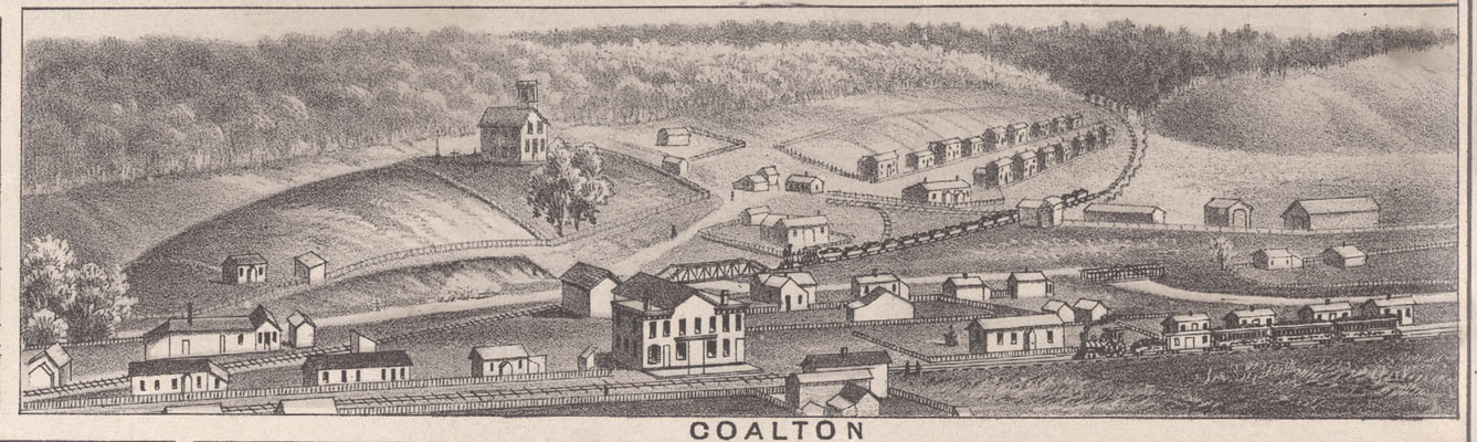
#1 Mine – This mine was at Coalton, and production commenced in about 1865.ACI, p23 I suspect it was never actually called the #1 Mine until sometime later when the #2 Mine at Coalton was established. Coalton became a significant drift mining operation, and eventually included parts of both the Big Run and Trace areas that butt up to the Coalton area. Short spur railroad lines ran southward toward both Big Run and Trace, to what eventually became the main Ashland to Lexington tracks running along Williams Creek. My Great Grandfather, John C Coleman (b 1851), worked as a miner at an AC&I mine at Coalton.
 The general area around the mining operation at Coalton. Note the loaded coal train in the image center coming from the Big Run area to the main AC&I / C&O tracks along the image bottom. Also note the large centered building on the main tracks. This building served as both the train depot and the mining company store. Click on the image for a larger view.
Click on this link for the approximate location of the depot / company store noted in the image above (at red teardrop marker).
_____________________________________________________________________________________
#2 Mine – This mine was at Coalton and was somehow part of that large mining complex described in the #1 Mine listing above. Later mining records clearly cite the #1 and #2 Mines being at Coalton, but I cannot differentiate a more specific location of either mine. The 1885 Kentucky Inspector of Mines Report, page 10, indicates that 100 people worked at the Coalton #2 Mine, and that it opened in 1883.KY, Annual Report of Mines, 1885, p10
______________________________________________________________________________________
#3 Mine – At Coalton. In a 1924 document listing the assets of the AC&I for the sale to the C&O Railway, a rail side track going to the #3 Mine at Coalton is listed as an asset.
______________________________________________________________________________________
#4 Mine – Very likely at Coalton. In the same document mentioned for the #3 Mine, this side track at Coalton is cited as “COALTON SPUR TO MINES NO. 1-2 AND 3:-“. It looks like someing has been mistakenly not typed at the end of that line, very likely the number 4.
The Rush area mines were developed a few years after the #1 mine at nearby Coalton and there are numerous citations indicating the first mine at Rush became the #5 Mine, so the #4 Mine was likely developed just a bit north at Coalton.
In a 1917 AI&M Federal Income tax brief asking for tax relief, all of the mines in the general area of Rush are listed (Mines #1 to #12, excepting Mine #8). This includes the #7 mine that was not specifically in Rush, but at nearby Grant. The #4 Mine is listed as being in the Rush area. Coalton would meet the criteria of being in the general area of Rush, just like Grant.
Congealing all the above leads me to believe the #4 Mine was at Coalton.
______________________________________________________________________________________
#5 Mine – The AC&I Rush #5 Mine is mentioned in the 1885 Kentucky Inspector of Mines Report on page 10.KY, Annual Report of Mines, 1885, p10 It indicates 403 people are working there and the mine was opened in 1871. In the 1889 Kentucky Inspector of Mines Report, page 31, there is mention of an accident at an AC&I mine in Rush at a “Bank 5”.KY, Annual Report of Mines, 1889, p31
 #5 Mine at Rush. You can see the tipples for this mining operation, loaded rail coal cars, loaded mine “tram” cars pulled by bank mules, a tram road extending south toward Blackleg Hollow, and the rows of mining company owned housing in a community called “Jim Town”. The larger tipple is for coal. The smaller tipple, to the left, was likely for clay. Also note that this image shows what was then the end of the line for the main railway from Ashland (look at image right center). In 1872 the railroad was extended southward along Williams Creek, from Coalton to the #5 Mine at Rush.ACI, p23 In 1881 this rail line was extended westward along Williams Creek to connect at Denton to the line coming from Lexington KY.Patrick, History of Ashland, p46 Click on the image for a larger view.
____________________________________________________________________________________
#6 Mine – This mine was in Rush, commenced operation in 1890,KY, Annual Report of Mines, 1890, p47 and was exhausted by 1903.KY, Annual Report of Mines, 1903, p153 A side track, off the main Ashland to Lexington railroad, serviced the coal tipple here. The image below shows this tipple used for the #6 Mine, which looks identical in both appearance and location terrain to the tipple in the image shown above for the #5 Mine. So, it is extremely likely that the #5 and #6 Mines used the exact same tipple, and that the #6 Mine was a bit south of the #5 Mine. This places the likely location of the #6 Mine in the Blackleg area of Rush.
Atypical long mine shaft(s) followed the coal seam, from Blackleg Hollow in Rush, and went east under the hill at the head of Blackleg to the Left Hand Fork of Trace Creek. There is a hollow in that area called “Shaft Hollow” or “Shafts Hollow” that had a vertical shaft from the hollow’s ravine, intersecting the long horizontal mine shafts following the coal seam below. This vertical shaft existed for ventilation of the unusually long shaft following the coal seam. This vertical shaft provided fresh air to those working in the unusually long shafts following the coal seam. One vertical shaft is still in existence.
Drift coal mines in the Trace area moved the extracted coal, using the long mine shafts that followed the coal seam, back to Rush for loading at the railroad tipple.
In 1889 the average number of employees for the #6 Mine was 216.KY, Annual Report of Mines, 1889, p124
My Great Grandfather, Tom Tiller, had his leg broken in the #6 mine on 6th Nov 1900. The annual mining report indicates “Thomas Tiller, a driver, while helping another take down a standing shot, had his leg broken”.KY, Annual Report of Mines, 1900, p53

 This two story brick building is the AC&I and later AI&M “Company” store at Rush. It was located at the mouth of Blackleg, so it would have been very close to the #6 Mine. The miners received script as pay that was used for purchasing items at this store. The building immediately to the left was a stable for the necessary mules and ponies used in the mines. The smaller frame building on image right is a mining company office. After the mining companies abandoned these structures the brick building was used as a general store in the 1930’s and 40’s operated by the Ratliff and Chapman Families. The office structure to the right became the US Post Office for Rush for several years. A maternal aunt, Minnie Tiller Gee (1922 – 1997), was postmaster there in the 1940’s.
Location of the AC&I / AI&M Company Store at Rush (at red teardrop marker)
________________________________________________________________________________________
#7 Mine – This mine was at Grant Station in eastern Carter County, and commenced operation in June 1893.KY, Annual Report of Mines, 1893, p84 A side track off the main Ashland to Lexington railroad running beside Williams Creek serviced a tipple there. There was a long strike at this mine in 1894 and the tipple was burned.KY, Annual Report of Mines, 1894, p82 In 1899 the average number working at the #7 Mine was 136.KY, Annual Report of Mines, 1893, p127
 The tipple for the #7 Mine at Grant. Click on the image for a larger view.
Click on this link for the general area of the #7 Mine operation at Grant (at red teardrop marker).
____________________________________________________________________________________
#8 Mine – This mine was at Winslow, and was sometimes called the “Clinton” mine. This mine had previously been owned by the Means Family and was later numbered for integration into the AC&I / AI&M corporate family, of which the Means Family were also principal owners. A side track off the main Ashland to Lexington railroad running near Little Hoods Creek serviced a tipple here. In 1889 the average number of employees for the #8 Mine was 67.KY, Annual Report of Mines, 1889, p124
The general area near this operation is referred to as #8. The current road running near this mining area, beside Little Hoods Creek, is now referred to as “Roberts Drive”, but before this road obtained this “official” name it was commonly referred to as the “#8 Mine Road”. My Great Uncle, Jack Clark (1885 – 1975) and wife Minnie Bunch Clark (1891 – 1992) lived very close to the area of the #8 Mine. If you asked Uncle Jack where he lived he would reply, “#8”.
 Main tipple for the AC&I / AI&M #8 Mine in the Winslow area of Boyd County. The very small part of track in the lower right is the main AC&I / C&O track running from Ashland to Lexington. Click on the image for a larger view.
__________________________________________________________________________________
#9 Mine – The 1917 AI&M Federal Income tax brief asking for tax relief mentioned above in Mine #4, also lists the #9 Mine as being in the Rush area.
__________________________________________________________________________________
#10 Mine – This mine was in a hollow in Rush and commenced operation on 2nd Aug 1899.KY, Annual Report of Mines, 1899, p15 In 1889 the average number of employees for the #10 Mine was 88.KY, Annual Report of Mines, 1889, p127
The mouth of this hollow is in Boyd County, but just a short distance west into the hollow you encounter the Carter County line. Further west and just over the ridge at the head of the hollow, you would be very near the railroad right of way which follows Williams Creek (C&O – Ashland to Lexington Route). There was a tipple in Carter County on a side track to this main AC&I / C&O line. The hollow in Rush is named for this mine and called simply #10. In 1956 I was a 5 year old living near the mouth of the #10 Hollow beside Rush Creek. Many years later my retired parents, George Coleman (1912 – 1991) and Frances Tiller Coleman (1921 – 1999), purchased a house and lived in that exact same location until their deaths.
The area in Carter County along the AC&I / C&O railway, around where the #10 mine tipple was located, is also called #10.
 Tipple for #10 AC&I / AI&M Mine in Eastern Carter County. This tipple serviced the #10 mining area that included a hollow in Rush and parts near the main AC&I / C&O railroad line from Ashland to Lexington following Williams Creek in Carter County. Both the area around this tipple in Carter County and a hollow in Rush in Boyd County are referred to as #10. Click on the image for a larger view.
________________________________________________________________
#11 Mine – This mine was in Rush, and commenced operation in 1902KY, Annual Report of Mines, 1902, p161 and was exhausted by 1906.KY, Annual Report of Mines, 1903, p153 There is also a hollow in Rush named for this mine called simply #11. I had cousins, the children of Enoch “Bud” Evans (1908 – 1978) and Grace Coleman Evans (1914 – 1978), that lived in the #11 Hollow at Rush in the 1950’s to the1970’s.
_______________________________________________________________________________________
#12 Mine – This AI&M Mine was near the head of Rush Creek and commenced operation in about 1905. This operation drift mined the area at the head of Rush, and an atypical long shaft went east through the hill at the head of Rush to the Four Mile Creek area. Other drift mines in the Four Mile area moved their coal though this long shaft from Four Mile back to Rush, for loading onto a railroad spur line that ended at the head of Rush. The railroad tipple for this operation was at the terminus of this spur line along Rush Creek, near where current SR 854 starts out of the Rush Creek hollow, up Rush Hill, toward the Garner area.
Rush local Harold Bates recalled his father, Arthur Bates (1900 – 1985), speaking of the shaft that went from the original part of this mine at the Head of Rush to the later Four Mile area. His father was amazed at the execution of this shaft. The shaft was completed by working from both sides, using both the already established shaft on the Rush side heading east, and a new opening on the Four Mile side heading west. Arthur Bates indicated the two parts joined perfectly and the surveying / civil engineering to accomplish this precise intersection of the two parts was quite special for Arthur. The 1917 AI&M Federal Income tax brief asking for tax relief, cites a cost in 1916 of $8,535.24 for the Four Mile entry.
Arthur Bates worked in area mines until he retired from Big Run Coal and Clay Company at Princess when he was 64, in 1964. Several decades after this mine closed a young Harold Bates and his father visited the Rush side mine entrance area to examine the ruins of that activity but found little. The huge slate dump for this mine remained visible until the 1970’s. The local school bus for Rush turned around in this huge flattened slate fill beside Rush Creek.
My Grandparents, Lon Tiller (1901 – 1949) and Lillie Clark Tiller (1902 – 1970), lived in the area near where the #12 Mine operated. In the 1950’s and 60’s my Uncle, Dick Tiller (1928 – 2010), extracted scrap iron and steel from the Four Mile side of this long abandoned mining operation.
The parents of my friend Curtis Hamilton, Charlie Hamilton (1912 – 1999) and Gladys Pope Hamilton (1916 – 1995), lived on Four Mile Creek, and attended church at Rush in the early 1930’s by traveling through this long mine shaft in a mine rail car from Four Mile Creek to Rush Creek. Curtis indicated others in the Four Mile area also used this long mine shaft to get to and from Rush.
 AI&M #12 Mine at the “Head of Rush”. Note the “Mine Shaft” near the top about 1/3 from the right image edge. This atypical long shaft went eastward under Rush Hill, and the other end of the shaft opened in the Four Mile Creek area. Coal mined in the Four Mile area was moved through this long shaft for loading at the tipple on the railroad spur line shown in this drawing. You can also see Rush Creek and another very short “Hull Spur” that went to a nearby independent coal mine operated by George Hull. Click on the map for a larger view.
___________________________________________________________________________________
The photo below is from the “John Means Collection” at the Boyd County Public Library. The photo is identified as being from an Ashland Iron and Mining (AI&M) mine at Rush. The exact mine or year is not specified, but it shows the very rough nature of the drift mining operations there. Click on the image for a larger view.

Thanks to James Kettel at Boyd County Public Library for his kind and focused help with the image of the #10 Tipple.
If you have any additional information on these AC&I / AI&M operations please contact me using the comment section below.
The images for the #1 and #5 Mines are from a large lithograph of Ashland KY.
The images for the #6, #7, and #8 Mines are from a publicity publication for the AC&I Railway.
The image for the #10 Mine is from from the image collection in binders at the Boyd County Public Library.
The map for the #12 Mine is from the US Interstate Commerce Commission Valuation Maps for American Railroads from 1916 for the AC&I Railway. These original maps are located at the C & O Historical Society at Clifton Forge VA.
Enjoy! Lon
Next Article: The Mix – Iron Ore, Carbon, Limestone, Air, and Energy
Previous Article: Lick Branch House Photo Family Confusion
I did some random searches and found a reference to mine No. 9 in this Ky Inspector of Mines report from 1900 (p.128). It seems to imply that No. 9 was somehow connected or at least inspected at the same time as No. 7 (Grant Station).
https://books.google.com/books?id=3GM3AQAAMAAJ&pg=PA128&lpg=PA128&dq=%22ashland+coal+%26+iron%22+%22no.+9+mine%22&source=bl&ots=pqKyzX5ZN-&sig=ACfU3U17i3T2cINXi97Ugoy3346pLGjIpg&hl=en&sa=X&ved=2ahUKEwjY2tbbh_jqAhUvmuAKHXmDAHQQ6AEwA3oECAQQAQ#v=onepage&q=%22ashland%20coal%20%26%20iron%22%20%22no.%209%20mine%22&f=false
Don, Thank you so much for your kind help on the mysterious #9 mine.
I think it is actually the 1899 Report, page 128.
The info is confusing. I am not sure how to deal with it.
Enjoy! Lon
Very interesting information about the area I spent my childhood. Do you remember a small tipple in Cannonsburg? It was on one of the four corners. I remember the noise it made when it operated, but it didn’t operate often.
Yes, I remember that tipple. I believe this tipple was used for area coal stripping operations. Possibly Charles Herbert Woods and his son Charles Herbert JR may have been involved.
Enjoy! Lon
i appreciate this brings back memories late 60searly70s my dad worked for Joe Warman on the Garner side in a truck mine
Hi Roy,
How serendipitous. In the coming months I will likely have access to some nice images of Joe Warman’s mine on Garner. Possibly I may do a short article on that operation, likely one of the very last shaft mines (not stripping) in the area. Can you ID exactly where the mine was located on Garner?
One of Joe’s grandson’s is my 2nd cousin, once removed.
Enjoy! Lon
Lon Joe Warman was my papa Joseph Calvin(Cab) Armand great great grandfather. The Warmans on Trace are my family. Wow.
I am unfamiliar with this region and its history. The detail in this article is exquisite.
Well your are the human that indicated I should write about someing I know. Bad Greg.
Enjoy! Lon